
Article published on 18/05/2017
Contact the editorpublished inn°154july / aug.
purchase
At the beginning of June, the crew of the catamaran Jangada headed for the Louisiade Archipelago, named by Bougainville in honor of his king, Louis XV. They had to cover 850 miles to reach the passage just south east of the Tagula Island lagoon…
The Coral Sea is the expanse of ocean which is situated at the far west of the Pacific, and which reaches as far Papua New Guinea and its archipelagos in the north, the islands of Micronesia and the Solomons to the north east, Vanuatu and New Caledonia to the east, and to the south, the north east coast of Australia. It is the numerous coral reefs in this area which have given the sea its name.
The Louisiades are a mixture of islands and reefs linked to Papua New Guinea. PNG does not have a great reputation. Never mind the sharks, sea snakes and the salties (sea crocs), there are now pirates and other low life which need to be added to the equation in these far off waters. Because of this, our stopover in “continental” PNG will unfortunately be of a very reduced nature. From the Louisiades, we will head straight for Port Moresby (and its secure, colonial yacht club), and then head out to sea and the Torres Strait, without hanging around in a town which is at number 5 in the list if the world’s most dangerous places ! There’s no way that I’ll expose my family to the worst of human nature…
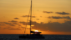
Our first night out at sea. The sea is so calm and shiny that the stars reflect in the water all around the boat in a slow magical dance. It’s a beautiful and unique thing to see. It was a rare event that I had never yet experienced out at sea.
However, a swell suddenly arrived from somewhere to the south, which woke the crew from their slumbers. A black squall had taken residence right above us. The weather started to get worse. There were two reefs in the mainsail and we were battling against strong winds and rain! A few hours later, Jangada found herself in a terrible zone full of squalls. On all sides we were confronted with low banks of cloud, each one darker than the other! Then things got worse. I suddenly spotted a waterspout, forming in the wind of the squall which had just left us a few minutes previously! It was no more than 2 or 3 miles away. We watched the phenomenon for several minutes. The sea was raging to the right of the monstrous spout which climbed up into the sky. And then the spout disappeared. It had lasted 5 or 6 minutes… For around 15 hours, we weathered torrential rain mixed in with strong gusts of wind, on a dark, uninviting sea. We made constant maneuvers in an attempt to head west, as it seemed that that was where a particularly lively tradewind was picking up. After each maneuver, the dripping wet crew would head under the relative sanctuary of the coachroof, to drink tea, dry off and dream of southern seas. The real ones, that are hot and sunny! Well there’s no doubt that the western Pacific has a few surprises up its sleeve! Over the last few months and over several thousand miles, I had been learning all about its nasty side…
The next day, a southerly wind picked up across our gray sea, usually the sign that the tradewind was returning. The mainsail and the gennaker were quickly put to work. We were soon showing 8/9 knots and the Captain had the smile back on his face! We were en route for the Louisiades and Jangada had just picked up the forecast downwind conditions.
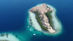
We were approaching land. Initially, we had thought that we would pass between the islands of Rossel to the north and Tagula to the south. Both are situated in large lagoons. Rossel’s is 45 miles long whilst Tagula’s is even longer at 112 miles! Yes, 112 miles. A 200km long lagoon! It was here that we would spend our two weeks. The smaller islands, islets and coral reefs are innumerable. We only sailed during the day, keeping a watch on the spreaders, as the lagoon is full of surprises, most of them bad ones. However, as we arrive by night, and it would be dangerous to try and pass between the two islands which are only a few miles apart, and with the strong currents in the region, I decided to go around the northern coast of Rossel. We would then need to sail 2 or 3 miles downwind of the barrier reef, before arriving 3 miles from the passage at daybreak. Once in the lagoon, it should feel a bit more holiday-like, and our first little island paradise was called Nimoa Island.
The night passed slowly. 12 hours of darkness is a long time. When the land is close it’s difficult to close your eyes knowing that the barrier reef is only 2 miles downwind. The navigational computer was on all night, controlling the work of the pilot given the drift because of the currents. We approached the Hudumuiwa Passage, where the dark blue water of the passage contrasted with the surrounding turquoise. We slowed down to observe the conditions in the passage. There was nothing to worry about. We were close to the low tide slack water. Marin took up his post in the spreaders, I took the controls, and at around 11am, we headed into the narrow passage. Once in the lagoon, the sea was calmer and the swell had gone. While going through the passage, I noticed an error on the electronic mapping system of about 0.3 miles (500m) at 285°. In the distance we could make out the outrigger canoes under sail. We headed around the northwest tip of Nimoa Island. In the bay, in the wind off the island, we caught sight of a small village constructed from bamboo and pandanus, up on stilts. It was next to a white sandy beach lined with coconut palms. We steered around the coral to find the passage which would lead to our anchorage. I went aloft to guide Timothée who was at the controls. Marin lowered the anchor in our provisional anchorage. We put the dinghy in the water and set off with a mask and a handheld electronic sounder. We noted a zone to avoid in the 360° surrounding us, because our experience of the squalls at our previous anchorage and the trouble that we had near Limu Island in Tonga were still fresh in our minds. We placed a grappling hook with a floater where we felt would be the ideal anchoring spot and then went back to our boat to put the boat and the anchor in the chosen position. A dugout canoe had left the village and was heading towards us. This long journey will always be a magical memory for me. We had arrived in the home of the Papuan people!
Welcome to Papuan Country…
At the end of the world there is an archipelago which is deprived of just about everything except happiness. I had never heard about it.
One of my secret hopes is that when, in a year’s time and they are back in France and walking down a shopping street full of shops laden with objects, clothes, food and any other consumables, (all supposedly useful or necessary but more often than not useless or superfluous), my children will think back and remember the happiness of those Papuan children in the Louisiades archipelago. They had so little, and of course no money, yet they seemed so happy… You could résumé our two weeks of discovery in the Louisiades in the following way: Should we live in a village on the water’s edge, with practically no material possessions, but surrounded by a generous Nature, in an effort to recreate their happiness? Obviously we can’t just say yes like that. Yet what we saw in these islands is certainly food for thought…
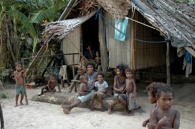
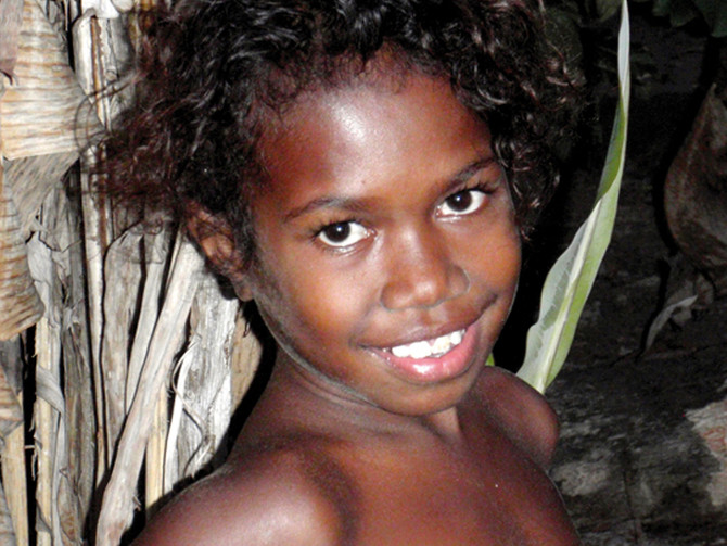
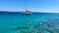
At the end of the bay there were houses raised on stilts, dugout canoes pulled up on the beach, and the silhouettes of children running around and excited by the arrival of an unknown boat. Through the binoculars I could make out some black pigs and chickens which were pottering about looking for food. There were a few skinny dogs too, hanging around. Yellow-crested cockatoos were screeching at each other in the trees. Bright red parakeets flitted across the bay. The kids would love to have jumped into Nimoa’s blue waters, but we were still a little unsure about three of the animal species which shared these waters: The ever-present sharks who we have seen virtually every day for months now and who we are very used to now; the sea snakes who we see swimming on the surface from time to time, and some new neighbors in our marine backyard, who apparently are very welcoming: salties! The salties come over from the north Australian coasts via the numerous coral reefs of the Torres Strait. They are sea crocodiles. They are considered to be some of the most dangerous animals on the planet.
- Ok kids, as far as swimming is concerned, you go onto the village beach and wait until we have found out a little bit more. Ok?
Is a calm life the secret of happiness?
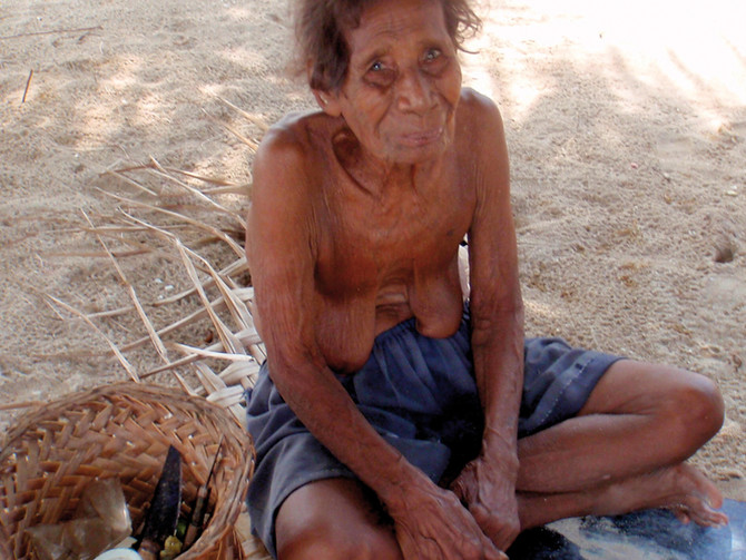
Along came our first Papuan in his outrigger canoe, a paddle in his hand. He seems friendly and is chewing betel, which gives his mouth a reassuring blood-soaked look! He speaks a few words of English and his name is John. He is the village chief, small and with mischievous eyes. He says hello to us in a reserved way. He doesn’t try to impose himself, yet he seems very curious. He was just coming to see who was arriving on his island. Human contact in the Louisiades would always be like this: reserved and more distant than on Vanuatu. The language is also a problem. English is less spoken than the local dialects. We say that we will visit his village when the sun is lower. In the meantime he tells us that we can swim in the bay. There are sharks but generally not aggressive ones, and because of the lack of mangroves, there are no crocodiles on Nimoa. This is good news. Sometime later we landed on the small beach. The locals all looked at us. There was no aggression, simply a world of difference between them and us, between their civilization, way of life, their level of development and our own. And we all knew it. John presented us to his wife, who gave us a big, betel-red smile, which was almost sexy, and his sons who were working on a canoe with some other boys. It was a large canoe with a sail that was being pulled on some logs in front of the houses. There were many children, but they too were reserved. They were easily scared by us. A rapid gesture by us and they were gone. All the houses here are on stilts, and it must be nice to sleep there, even on mats, with the breeze of the tradewinds blowing. Small separate blocks close to the houses are used as kitchens. There is the usual selection of white iron pans, and boiling pots that were blackened by smoke, along with many carved, wooden utensils. There are many cutlasses and machetes, and the men always have one with them which they use all the time and for everything. The Papuans use lots of fibers from the forest in their everyday lives and in particular in their homes, their boats and their gardens.
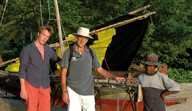
John reassuringly accompanies us through the village. Quite soon he raises the question of bartering. There is no shop for stocking up on the Louisiades, not one, and the villagers produce practically nothing which could encourage money to flow through the island, apart from some red coral necklaces and some wooden carvings. These go to Misima and then on to mainland PNG where they help to pay for the rice and flour that the villagers need. Also, the mainly Australian boats that sometimes visit the archipelago usually don’t have Papuan money (the currency is the kina). This is the case with us: we had arrived from Vanuatu, our stopover in the Louisiades was unofficial and incognito, and the nearest Papuan bank was several hundred kilometers away from the archipelago! As no shipping company serves these isolated islands, the people are practically self-sufficient. From time to time the villagers send their largest craft to stock up on a few things on the larger island of Misima, about 10 miles away. They buy staple foods, machettes and fishing hooks. In exchange they take with them langoustines, bananas, papayas, pigs, basketwork, bracelets and some handicrafts. I am fascinated to watch the outrigger and sailing canoes used by the villagers to get between the islands. These are symmetrical craft, with the outrigger always to the wind, but doing both jobs depending upon the direction of the craft and the wind. The rigging which holds up the patched up sail, pivots around a mast depending upon the wind strength and direction. There is not a single piece of metal in these canoes which are capable of maintaining speeds of 7/8 knots in a steady breeze. Everything is natural, made from wood and ties made from natural fibers. The main body of the canoe is carved out of a trunk. The sails are made from linoleum flooring, old tarpaulins and patched up bits of material. They in turn are lashed to their spars. Curiously, these canoes do not have any directional system, even one that can be removed. The Papuan sailors use a simple paddle rudder, itself attached with a simple tie. The helmsman has a very physical rôle. He needs to find a tricky equilibrium aft, and he manipulates the paddle rudder with both arms, with the help of one of his legs which he crosses over and with which he pushes down on the trailing edge of the paddle. Sometimes the Louisiades canoes do journeys of tens of miles in the big lagoon. These craft, usually 4 or 5 per village, are the main form of transport in the archipelago. For fishing and short individual journeys, they use dugout canoes, with or without an outrigger, pushed along by single or double paddle. Often the women will use their own canoe on calmer waters to get to gardens outside the village, from where they will bring back their harvest of yams, taros, sweet potatoes, beans, papayas, lemons, green oranges and pineapples. The women also pick up shellfish on the shore. The men harvest the coconuts. They all seem to be able to shin up a coconut palm from about the age of 7 or 8. Taking the top off a coconut is a physical job that the men seem to be able to do with a speed and dexterity which I can’t take my eyes off. They also go fishing in the lagoon with fish hooks but also with spears (metal spikes lashed to some bamboo). Later on I discovered that they also do free diving fishing with rudimentary underwater crossbows that are about 2.50m long and equipped with a bungee cord, and cobbled together using their very basic means. When later on I thought back to how they looked on in fascination at our Beuchat spearguns, used by Timothée and Marin, I almost felt embarrassed.
Sailing In The Far Flung Corners of The Earth…
To get to the Louisiade archipelago, you will need a boat and a certain amount of autonomy (fresh water, fuel, energy, food), and a certain spirit of adventure.
Sailing in this region requires a minimum of attention. Imagine a lagoon 200km long and 50km wide, dotted with islands, some of which have their own lagoon within the lagoon. Depths are usually between 20 to 50 meters, however there are many coral formations and sand banks, which are not well mapped. I noted a general discrepancy of around 500 meters (although this wasn’t constant) on the electronic charts. This is a problem, and rules out any night time sailing. The swell from the sea outside the lagoon is broken by the coral reef which surrounds the lagoon, although this is less true at high tide. The currents can be quite tricky, especially at the passages, with the backwash pushed on by the island winds and where the water isn’t always very clear. In short, you need to keep your eyes peeled…


What readers think
Post a comment
No comments to show.