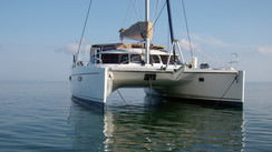


The Baltic - On an Astus 24
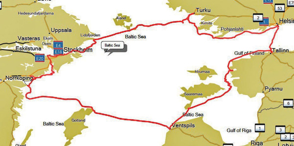
Destination - AtlanticAs the owner of an Astus 24 and based in Brussels, Belgium, Robert has decided to treat himself for the second time to a trip to the Baltic Sea, 1,500 kilometers (950 mi) from home. But he didn’t reach this wonderful nautical playground by sea: he spent two days on the road followed by a quick launch and then off he went for a (big) tour that covered over 700 nautical miles. His only limitation: time!
«From Brussels to Oxelösund we drove 1,500 km (950 mi), almost exclusively on the freeway. There is no charge for these - neither in Germany nor in Denmark. However, you have to take the ferry north of Hamburg: a 50-minute crossing. Booking is not compulsory: there are ferries every 30 minutes (night and day). Go for a combined ticket Puttgaarden (D)-Rodby (DK) and Helsinborg (DK) - Helsingors (S) or the Öresund bridge between Copenhagen and Malmö - a 100 km (60 mi) detour that is well worth making at least once. The trailer costs the most (depending on the length). As the journey is long, I made a stopover before Copenhagen at the small Tangloppen campsite, close to a metro line that in just 25 minutes will take you to the city center. There you can visit all the must-see places: The Little Mermaid, the old harbor... or go to the beach (fine sand) just 5 minutes’ walk away. On the road between Malmö and Oxelösund, (between Ljungby and Värnamo to be precise), the freeway turns into a 3-lane road: it passes through beautiful forests and there are good, well-equipped car parks in the middle of the woods. We found a public boat launch in Oxelösund (4 meters / 13 feet wide) with the possibility of leaving the car and trail er at a chandlery nearby. We paid just 70 € to have the car and trailer looked after for 2 months!
Why Oxelösund in Sweden? Admittedly, it is not the most beautiful of departure bases: the marina is opposite the industrial port. But Oxelösund is only one day’s sailing from Nyköping, a town served by an airport. It is therefore easy and inexpensive to make crew changes there. There is another possibility: launching at Motala, at the yacht club. The slipway is wider (5.25 m / 17’) and there is also the possibility of safely dropping off the car and the trailer at the yacht club car park. The staff of the club is very friendly. Last time I paid nothing for 45 days of parking. On the other hand, the launch in Motala involves sailing the Göta Canal to get to the Baltic Sea. It’s a lovely route on a canal dating from 1900 interspersed with lakes and locks (37). The trip can be completed in 3 to 5 days - perfect if you have the time.

The Baltic coast of Sweden conceals small, perfectly-sheltered ports
Heading for Latvia via Gotland
From Oxelösund, we weaved our way around the islands along the Swedish coast. Our first port of call was the island of Gotland, located halfway between Sweden and Latvia. We stayed there for three days in the port of Farösund, waiting for a favourable weather window for the longest crossing of the trip: nearly 90 nautical miles that we covered over a long day, finally reaching Ventspils, Latvia. This is an industrial port (coal and oil) with a new marina being developed a little further away. The city is full of contrasts: the old town, still very Soviet, competes with the new, more European districts. One great advantage here is that life is not expensive.
As far as navigation is concerned, I have large scale Admiralty charts for the crossing between Sweden and Estonia (in addition to my Garmin maps from my GPS). However, when sailing, I realized that I was missing some pieces. I discovered that it was possible to connect via internet on my iPad and follow my position in real time: Estonia, which has very good 4G internet, has digital nautical charts available for free: fantastic! We then made our way back to Tallinn, in Estonia; five weather-related legs were then necessary: Ventspils - Montu (41 miles), Montu - Kuivastu (67 miles), Kuivastu - Haapsalu (41 miles), Haapsalu - Dirhami (21 miles) and finally Dirhami - Tallinn (46 miles). The ports are often brand new and very quiet.

Around the 60th parallel North, nights are very short in summer...
Sailing to Tallinn by night
Our router (Weather 4.0) and that day’s grib files suggested we depart at 22:00, arriving in Tallinn in the early morning. This is where we met up with our French friends. The night was short and the scenery beautiful. The capital of Estonia did not disappoint us - the old paved and walled city, the gothic town hall and the famous St. Nicholas church are magnificent. But it is best to plan the visit early in the morning before the many tourists begin to disembark from the cruise ships.
On July 24th, we set off for a crossing from one capital to another: we completed the the 46 miles from Tallinn to Helsinki in 9 hours in lovely warm weather. We even visited the Finnish capital under a blazing sun and 28°C (82°F). Our schedule included the Lutheran cathedral, the orthodox Ouspenski cathedral, the Temppeliaukio Church and the Helsinki Market where you can buy your salmon for the evening. We then set off again towards Turku, in the north-east of the Öland Islands.
We completed the journey in 5 stages: Helsinki -Barösund (39 miles), Barösund - Jussarö (13 miles), Jussarö - Hanko (21 miles), Hanko - Portnasset (34 miles) and Portnasset - Turku (30 miles). The weather was changeable... we had some warm weather with light wind, but also some rougher conditions. We sailed between the islands, in channels marked out in the «Scandinavian» style, that is to say small, very discreet cardinal poles... Fortunately, the use of precise charts, regular checks and a good GPS with maps enabled us to sail serenely among the rocks! We liked Turku a lot: the 13th century city is crossed by the Aura river. When there you must visit Turku’s medieval castle, the Luastarinemäki craft industry museum and the cathedral which dates from the year 700.
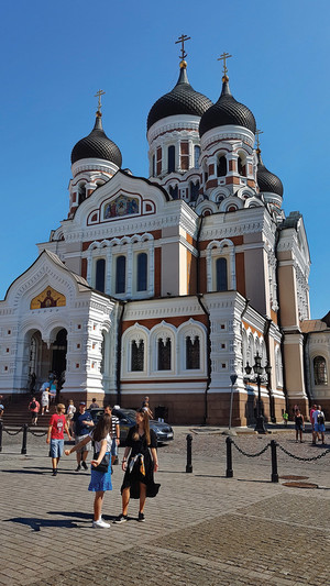
Tallinn, the capital and cultural center of Estonia.
From Finland to Sweden
Time passed quickly and we set off again for Stockholm. We sailed through a string of islands. Every evening, we prepared the route, using paper maps, the GPS tracker and the router. The latter, using simulations, gave us the chance to leave at the best possible time and in good conditions. In four days, we reached the Swedish coast: Turku - Nagy (20 miles), Nagu - Jungfruskär (31 miles), Junfruskär - Foglo (26 miles) and Foglo - Kapellskär (46 miles). This last crossing was eventful with winds of 25 to 30 knots and waves of up to two meters (6’6”). With one reef and in spite of our crew of four - not to mention our cargo - we managed to get up to 10 knots. We spent another five days sailing in the more sheltered areas of the Stockholm archipelago. At the beginning of August, the harbors are gradually emptying and the weather starts to change. Every now and again there was a shower or a storm. Our journeys became shorter: Kapellskär - Husarö (22 miles), Husarö - Ingmarsö (4 miles), Ingmarsö - Grinda (15 miles), Grinda - Vaxholm (9 miles) and finally Vaxholm - Stockholm (10 miles). Our pace had seriously slowed down and we were starting to take more time to appreciate our surroundings!

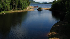
Dirhami : a lovely beach of fine sand. Perfect for lazing away the day!
Well sheltered on the Swedish coast
From Kalmar to the Stockholm archipelago, there are hundreds of islands, channels, nature reserves and wild anchorages. There are lovely small, well-equipped harbors all along the coast. I have discovered that there is a series of guides, unfortunately only in Swedish, which, for example, lists no less than 376 harbors and anchorages on the west coast. Once again, the GPS and chart working in tandem have been brilliant. It was easy for us to prepare the itinerary the day before and to navigate around the rocks. The small open anchorages are ideal with a trimaran like ours: 1.50 m (5 feet) daggerboard down and 50 cm (19”) daggerboard up. The Swedes often have a stern anchor and a long line on a roller. At the bow, you prepare a mooring line (make sure it is long enough) to moor either on a ring or to a tree trunk.
After visiting Stockholm, our friends got back on the airplane. It was just the two of us again sailing together back to where we set out from, Oxelösund. We left the Swedish capital via the Södertaltje canal to shelter from the wind that was blowing up on the coast. In August, the weather changes but the landscapes remain sublime: There were showers, clear spells, squalls, strong gales and lulls. It was time to end our journey. We opted for the Trollhatten canal: in three days we covered the 92 miles: Stockholm - Rastaholm (19 miles), Rastaholm - Skansholm (21 miles) and finally Skanholm - Oxelösund (53 miles).
The last magical moments of a wonderful six-week cruise...
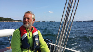
Robert de Thibault à la barre de son Astus 24.
En route with Robert!
Towing an 850 kg (1,875 lbs) lightship trimaran in reality means hitching at least 1,300 kg (2,870 lbs) to the vehicle - 350 kg (775 lbs) of trailer and a minimum of 100 kg (220 lbs) of equipment. And for Robert, that meant more like 300 kg (660 lbs) of equipment! Towing such a load requires the appropriate permits, a powerful and heavy vehicle and, of course, careful and smooth driving. At night, you can sleep in your multihull or in your vehicle if it is equipped.
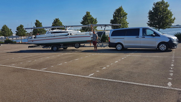
Robert is towing around 1,500kg (3,300 lbs) behind his vehicle
This second option is often simpler because access to the boat is not necessarily very easy - mast on the hood, height on the trailer and the inside cluttered up with all the equipment. Robert explained the sleeping arrangements: “During the journey, my co-driver slept aboard the minibus and I, the driver, in the berth in the Astus’ saloon. Inside, there are the sails, the boom and everything else in the forward cabin and on the port berth. Everything heavy (engine, liferaft and refrigerator) is in the minibus.
Weather and sailing conditions - The Baltic Sea in summer
Situated in northern Europe, the Baltic Sea laps the coasts of many countries: Sweden, Finland, Russia, Estonia, Latvia, Lithuania, Germany and Denmark. It’s a huge body of water: 364,800 km² (141,000 sq mi) with 7,200 km (3,900 nm) of coastline - yet no crossing exceeds 135 nautical miles. The water is not very salty - 10 g/l compared to 40 in the Mediterranean. In winter, the waters of the gulfs north of the 58th parallel can freeze... It is obviously in summer - more precisely in June, July and early August - that the Baltic becomes a more welcoming option. For a start, the water temperature reaches 12 to 15°C (54 to 59°F) from north to south, and even 20°C (68°F) in the shallower bays. Added to that, daylight exceeds 18 and a half hours out of 24 in Stockholm around June 21st. And during the very short night, it is not really dark, so it’s just perfect for sailing at any time! As for the temperatures in July, with an average minimum of 15°C (54°F) and maximums of 24°C (75°F), they are worthy of the month of May in Annapolis - or June in Venice... This central area of the Baltic Sea that was chosen by Robert is also relatively dry - only 500 mm (20”) of rain per year. The currents are weak and the tide negligible - about twenty centimeters (8”). In summer, the wind is rarely stormy and calms are rare - except in the deep gulfs. The prevailing wind is from the southwest. The sea is usually manageable, except in open areas where the fetch can be significant.
 |
 |
A series of guides lists no less than 376 ports and open anchorages on the west coast of the Baltic Sea - but they are written in Swedish.
Destinations offered by
View all the destinations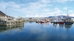
Norway, Land Of Legend and Fjords
Norway - Sailing in the wake of the Vikings!
Cabo Verde
South Brittany
Quebec
Subscribe and get 8 issues a yearfor just $39.90
subscribe
For all used-boats for sale
Classified ads
View classified ads
Sunreef 62 (Refit 2023) - v. owner 4 cabins - Excellent condition - Transat Ready
- Location :
- France
- Year :
- 2008
52' Custom Cruising Performance Cat AeroRig by Shuttleworth
- Location :
- Raymond, WA, United States
- Year :
- 2026
86' Custom Motorsailer Catamaran ready for your interior - 6 cabin en-suite
- Location :
- Raymond, WA, United States
- Year :
- 2027
What readers think
Post a comment
No comments to show.