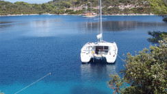


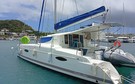
Helia 44 for sell, ready to sail...
- Location :
- Le Marin, Martinique
- Year :
- 2015
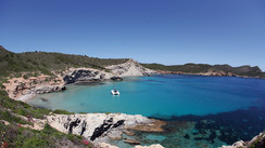
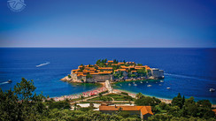
The largest of the Balearic Islands has an unfortunate reputation for concreting over everything… Thankfully, you will find that the massive urbanization undertaken in the 1980s is only limited to certain areas of the coastline. There are plenty of other places for you to enjoy the warm, turquoise waters, the sheer cliffs, the cicadas and the palm trees!
Arriving at Palma airport can send a shiver down the spine of even the most enthusiastic sailors (despite the warm temperature): an enormous terminal, an armada of buses and row after row of tourists. There’s no getting away from the fact that Majorca is one of the most popular destinations in the summer. And the town of Palma with its 400,000 inhabitants won’t change that impression. It is worth visiting the cathedral and the old town though. Your cruise will probably start here or in a nearby marina. As you would expect, the charter companies are based in well-equipped ports and close to airports. There are a number of possibilities open to you when setting out from Palma: Ibiza to the south, around 10 hours sail away and Minorca, a good half day’s sail to the east. However, Majorca has enough to keep you interested for a week or two’s sailing. Once you’ve got away from the concrete jungle of Palma’s bay, you will be faced with endless creeks, quiet anchorages, picturesque ports and especially the northern coast with its spectacular cliffs.
Majorca’s coastline (including a little detour around the Cabrera archipelago) is around 200 nautical miles long. Taking a full tour of the bays, and in particular the deep ones such as Alcúdia, will keep your multihull’s log pretty busy. It’s possible to do this route in a week as long as you don’t spend all day bobbing around at the end of a creek. There isn’t much planning needed either. However, in July and August it is better to have your anchorage for the night organized by late afternoon.
There is one piece of advice that we would give before you set off: unless the weather forces you to leave Palma and head east (anti-clockwise), we suggest that you head west (clockwise). Most of the guides that are available in English and French describe the ports and the available anchorages in a clockwise direction. It’s a little easier to follow the guide in the order that it’s written and not to have to read it backwards!
Here’s our suggestion for a week’s charter:
Party animals (or people watchers), might be tempted by Magaluf, which is the local version of Ibiza. A superb beach, and a sheltered bay, but there are surprisingly few boats… There are however, very large buildings. The town is dead in the morning, starts to come alive on the beach in the afternoon, gets going in the evening and goes mad at 3am! To the south west, Las Illetas is the first real, turquoise water anchorage. It’s packed and flat calm. Cala Portals with its three distinct creeks, and the wilder Cala Figuera are both suggested lunch stopovers. We recommend “Mediterranean” style mooring: the anchor out front and the stern secured ashore. Head on to Andratx for the night, a pleasant, well-sheltered spot.
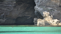
San Telmo beach, at the western edge of Majorca, sheltered by the island of Pantaleu is worth a visit. Opposite, the spectacular island of Dragonera also has some anchorages on the south east coast. You are now arriving on the north coast, and there will be very few anchorages before you get to the famous Foradada peninsula whose tip has a hole right through it. Spend the night at Puerto Soller, a unique and charming sheltered spot on the north coast.
Make the most of the morning’s relative calm to visit Cala Tuent, at the foot of the island’s highest peak (1455m / 4,775 feet), and then head east to the stunning Torrente de Pareis lagoon. Few villages or proper shelter, but lots of white, ocre and gold colors, and cliffs that seem to get steeper and more spectacular. Try Cala Castel at lunchtime. Hug the rocky coastline for another 30 miles, and you will see Cap Formentor, which offers protection for several anchorages and is home to an excellent spot to stop for the night: Pollensa.
To the north west, there are some nice locations in the Bay of Alúcidia, but you shouldn’t miss out on Es Calo on the other side of the bay. A partly-submerged little harbor, golden rocks, pine trees, turquoise water and hills rising to over 400 meters (1,300 feet): it’s a wild and wonderful environment. After passing more impressive capes on your starboard side, you will come across a number of anchorages, some of which are exposed to the east, and a lovely port at Cala Ratjada.
There is now a succession of bays and creeks to explore, from the wildest (Cala Barcas), to the most bling-bling (Cala d’Or). The most sheltered spots for overnighting are at Puerto Colom and Puerto Petro.
Your mission today is to reach the protected Cabreras archipelago! But only if you have pre-reserved on their website: www.reservasparquesnacionales.es. Most multihulls get a day pass to moor up as long as there are places available. You are not allowed to spend the night there. Then head out to sea towards Puerto Colonia de Sant Jordi. Just to the north west of Salines point, which is Majorca’s most southerly location you will find Cala Caragol with its lovely beach, surrounded by dense pine forest, the small Entugores Bay and more good anchorages between the rocks and the dunes at Playa des Carbo and Playa de la Roquetas. Before heading back to Palma, don’t miss out on the tiny Cala Beltran, and enjoy the turquoise waters of Cala Pi…
Getting There:
With over 22 million passengers per year, Palma airport is amongst the European top 20, and in summer it is one of the busiest. This means that it is easy to get there by air. And it becomes an even more attractive destination when the low-cost airlines that fly there are taken into account. You can also get there by ferry, mainly from Barcelona, Valencia and Denia.
When:
From June through September, the weather is pretty much always good. In other words, it’s during the northern hemisphere summer that the conditions are at their best. The average air temperature is 25°C (77°F), with average maximums of around 31°C (88°F), and the water can get up to 26°C (79°F). This doesn’t mean that you can’t sail at other times of year. The climate is pretty clement with an average air temperature of 11°C (52°F) in January, and the water doesn’t drop below 14°C (57°F). The weather is mostly dry and sunny, with just 400mm (16”) of rain and 2,750 sunshine hours per year. The only fly in the ointment is the wind. During the low season, the winds can be turbulent. The Tramontane which blows from the north/north-west hits the northern coast of Majorca, and the swell can reach two meters (6’). However, during the May to October period it isn’t unusual to get extended periods of calm weather, when engines will be needed. The southern coast and the bay of Palma in particular, are regularly influenced by southern sea breezes.
Sailing Conditions:
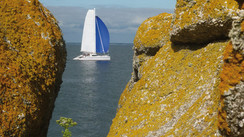
There is no tide and not much in the way of currents or shallows: cruising in Majorca is as fun as it is easy. The only things to watch out for are the swell and the chop, which render some anchorages difficult. As a general rule, you will probably want to take advantage of the multitude of bays and creeks (the calas). Pretty much anywhere you will have the possibility to moor up at a quayside and fill up the water and fuel tanks. Majorca has around 20 perfectly equipped ports. There are enough good, sheltered zones (apart from along the north coast) to afford a quick and safe bolthole. Along the north coast’s 50 miles of spectacular rocky cliffs, only Puerto Soller is a safe haven if the sea is too rough.
What readers think
Post a comment
No comments to show.