
Issue #: 196
Published: July / August 2024
- Price per issue - digital : 6.50€Digital magazine
- Price per issue - print : 9.50€Print magazine
- Access to Multihulls World digital archives Digital archives
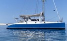
In MW186, we left the crew of Cat’leya, a Lagoon 52S, in the Bounty Heaven fiord as they discovered Fiordland, in New Zealand’s South Island. Here is the next instalment of their adventures in these breathtaking landscapes which are steeped in history.
Published 17/05/2024
Subscribers OnlyLess than 8 miles south of Bligh Sound lies George Sound, probably the most protected fiord in Fiordland. The Maori named it Te Houhou (the five-fingered tree), after its five arms, one of which leads to Alice Falls. We’re heading for the first arm, Anchorage Cove. With over 200 days of rain a year, or 275 inches/7,000 mm of water, the marine environment is exceptionally diverse and structured. The freshwater, which is less dense, takes up the first few fathoms below the surface. This layer is very tannic and often colonized by algae, providing very little light. Next comes the interface layer with the salt water, where the mixture of salinity impedes the progression of light and makes visibility almost non-existent. Below this is the seawater, where we find flora and fauna that would normally only be found at much greater depths. The entrance to the fiords, which is much brighter, has a more ‘normal’ seabed whose development is influenced by the ever-present offshore swell: white, black and red coral, cod, green algae, spiny starfish and tarakihi. We’re gradually getting used to navigating these channels bordered by high mountains, and even my drone, which can fly at up to 1,600 feet/500 meters, is nowhere near the peaks that surround us!
We leave George Sound and set sail for Charles Sound. Once again, this fiord was named by the Australian navigator John Grono, this time in memory of Charles McLaren, captain of the Sydney Cove, a seal-hunting vessel that navigated the fiords in the 1810s.
After a breezy night in Gold Arm (35 to 40 knots), we filled up with fresh water alongside a helicopter pad, where a pipe draws water from a nearby river. The next day, we set a course for the next branch of the sea: Emelius Arm. The night’s rain had created a plethora of waterfalls that lit up the steep, dark slopes around us. Our chosen anchorage is the River Irene estuary. We explored it in the dinghy and came across a «patrol» of black swans.
As we reached the entrance to Charles Sound, the birds alerted us to the underwater activity: bluefin tuna were hunting. It didn’t take us long to catch blue and red cod as well as two bluefin tuna!
The next day we departed Charles Sound for another fiord further south. The Māori name for this fiord is Patea, “the sound of silence”, but it was B ritish Captain James Cook who named it Doubtful Harbour on his first voyage to Fiordland in 1770. He thought it would be very difficult to sail out without an easterly wind, so he didn’t attempt to explore the area. After the rain of the previous few days, we were once again treated to a string of waterfalls all along Thompson Sound, the fiord through which we entered Doubtful Harbour. We decided to head for the very end, to Deep Cove, so named because it is so deep that there is no place to anchor. It’s a popular tourist destination and many charter boats organize excursions there. It is also possible to have groceries delivered ...


What readers think
Post a comment
No comments to show.